DAVAO CITY, Philippines—Maps have long been used to draw boundaries, rename territories and dispossess Indigenous peoples.
Researcher Rohan Fisher uses mapping technology for a different purpose: to help Indigenous communities tell their own stories about the land and shape how it is understood and protected.
“The maps are the stories of land, who holds the map and who creates the map are the people that have the power over that story of land,” Fisher said.
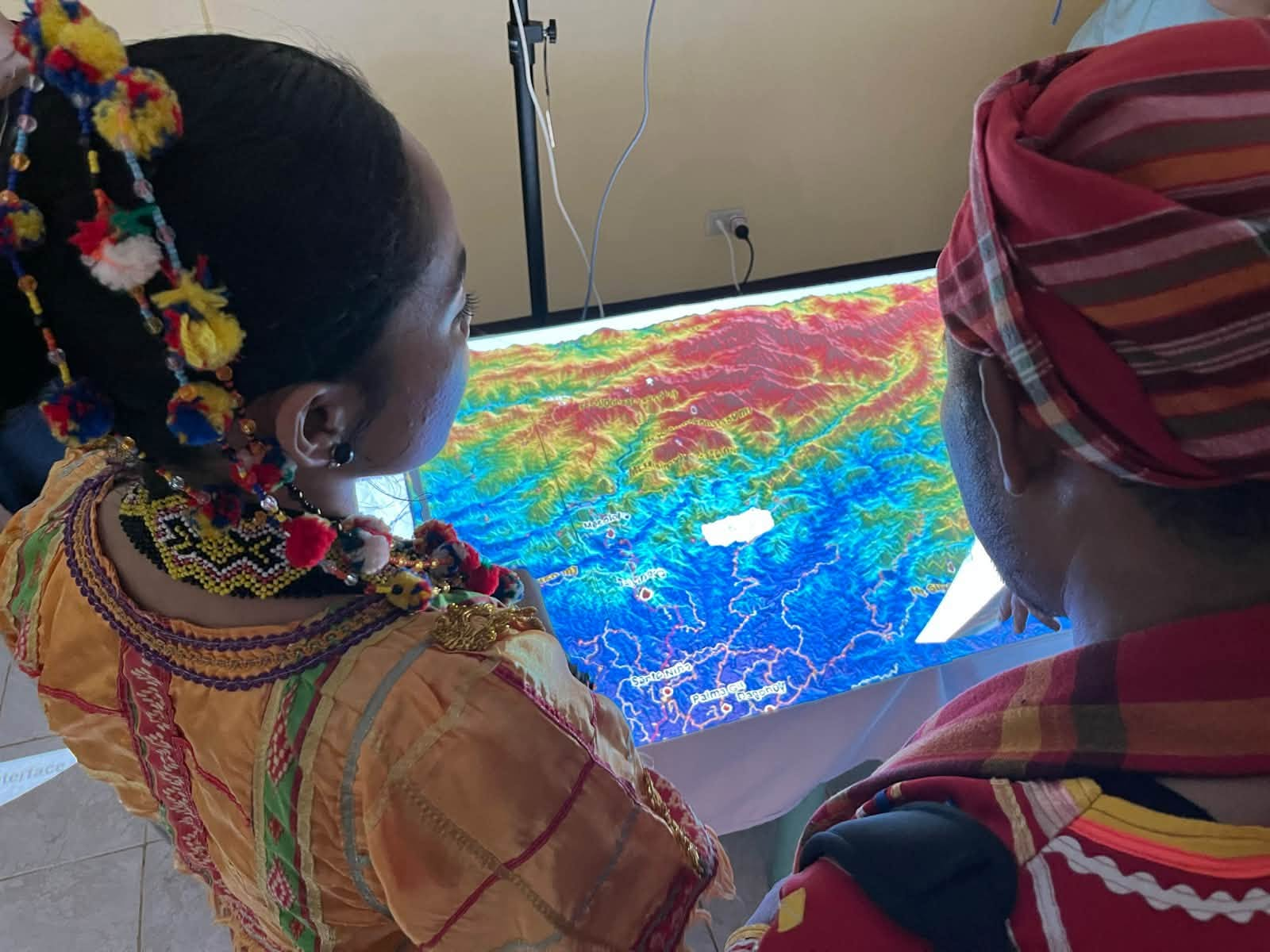
Fisher, a senior research fellow at Charles Darwin University in Australia, has been working with the Philippine Eagle Foundation (PEF) on Projection Augmented Landscape Models (PALM), which combine physical three-dimensional terrain models with projected digital information.
The technology was featured during Katutubo: Guardians of Ancestral Domains, a festival organized by PEF on Oct. 30 at the Philippine Eagle Center in Davao City.
Two of the models were turned over to Indigenous community representatives during the event. Datu Warnit Lumista received the map for the Higaonon community, while Datu Andigao Agay received the map for the Ata Manobo community in Talaingod, Davao del Norte.
Performance spaces
Fisher said maps have historically served as instruments of colonial conquest, allowing outsiders to impose boundaries and rename and define territories according to their own interests.
He wants the 3D models to help shift that relationship by giving Indigenous knowledge holders a way to present their own understanding of the landscape.
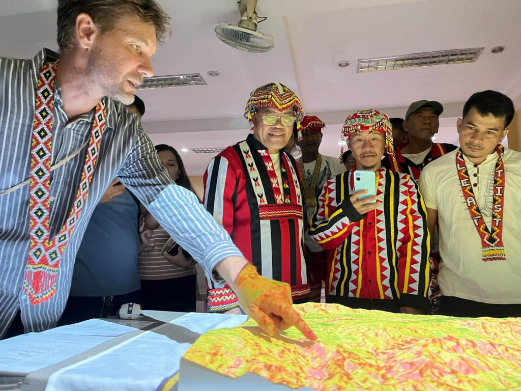
Fisher described the models as “performance spaces” where knowledge is shared and discussed, rather than fixed records of information. He said knowledge about the land is not static. It changes, develops and is passed between generations.
The models are meant to support that exchange instead of treating Indigenous knowledge as something that can simply be collected and stored. Physical models allow people to see and interact with terrain in ways that can be difficult to achieve through conventional maps or digital screens.
The shape of the land can help communities discuss where water flows, where animals move, where people travel and how different areas relate to one another.
The models can also incorporate information across time.
Fisher cited the example of tracking an eagle’s movement from its nest over the course of a year, allowing communities to see how an animal moves through a landscape.
He described this as a way of creating four-dimensional models, adding time to the three-dimensional representation of a place.
PALM combines physical terrain models with projected digital information, animations, and simulations. Charles Darwin University’s description of the technology described the approach as a way to make complex landscape information more accessible for participatory planning and knowledge exchange.
The university has also documented earlier work involving Fisher, PEF, and the Obo Manuvu community of Tambobong in Davao City, exploring the technology’s use in ancestral domain planning and community-based environmental management.
The project hopes to reach more Indigenous communities, but its expansion will depend on funding. Organizers are still looking for resources to develop additional maps for other communities.
Mapping helps assert land rights
The Philippines is not new to using three-dimensional models in Indigenous land management.
In Mindanao, participatory 3D mapping has helped Indigenous communities document ancestral territories, identify natural resources, and take part in decisions involving their land.
The International Land Coalition has documented participatory 3D mapping initiatives facilitated by the Philippine Association for Intercultural Development (PAFID), which used participatory mapping to support Indigenous communities’ formal claims over ancestral domains.
These maps documented rivers, forests, agricultural areas, and other resources. Their digitized version also helped communities prepare formal claim documents and assert their right to free, prior, and informed consent.
One documented example involved Higaonon and Talaandig communities in Pangantucan, Bukidnon. A 1:5000-scale 3D model completed in 2000 represented a claimed ancestral domain covering 288 square kilometers.
According to the Integrated Approaches to Participatory Development’s (IAPAD) account of the Higaonon and Talaandig mapping project, the model helped communities gather evidence supporting ancestral domain ownership, address boundary conflicts, delineate territories, and prepare an ancestral domain management plan.
Another initiative involved the Agtulawon-Mintapad Higaonon community in Impasug-ong, Bukidnon. A 3D model covering 10,054 hectares was developed between 2001 and 2004, incorporating forests, rivers, waterfalls, and sacred spaces.
The mapping process helped the community determine past, present, and future land use and address boundary conflicts. The resulting maps also served as a common reference in negotiations with government agencies and other groups, as documented in IAPAD’s account of the Agtulawon-Mintapod Higaonon mapping initiative.
These cases involved earlier participatory mapping methods and are not evaluations of Fisher’s current PALM project. They nevertheless show how community-led mapping can serve purposes beyond visualizing terrain, including documenting land rights and supporting Indigenous participation in decisions over ancestral domains.
Conservation leaders
The Katutubo festival was organized around the role of Indigenous peoples in protecting forests and biodiversity.
PEF said ancestral domains are not only homes and sources of livelihood but also landscapes where cultural traditions, Indigenous knowledge, and wildlife are deeply connected. Many of these territories provide critical habitats for the Philippine Eagle.
The festival sought to provide a platform for Indigenous communities to share their conservation achievements, challenges and aspirations while strengthening partnerships with government and conservation organizations.
Its program also highlighted knowledge exchange between Philippine and Australian Indigenous practitioners, including women’s leadership, ranger programs, traditional knowledge preservation and the use of conservation technologies.
PEF identified 16 Indigenous partner communities for recognition during the gathering. The program also included a collective declaration on safeguarding domains, biodiversity and future generations.
For Fishers, the collaboration grew from an earlier encounter with Indigenous elders from the Philippines who visited his university and laboratory in Australia two to three years ago.
He initially wondered whether the work would be useful to them. But the elders quickly recognized ways the models could be used to their communities.
That experience helped shape his understanding of the project: technology has little value on its own unless communities have a clear purpose for using it and can connect it to their own knowledge.
“There is value in science. There is value in engineering. But they’re not of more value than those other stories from the land,” Fisher said. (davaotoday.com)