by Davao Today
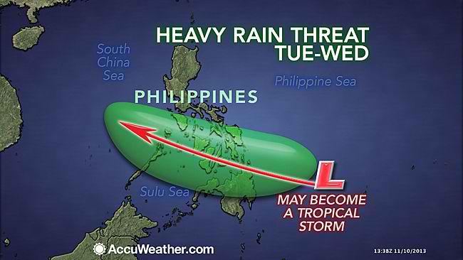
Davao City – In the wake of the devastation left by Typhoon Yolanda (international name Haiyan) in the Visayas province over the weekend, another tropical disturbance threatens Visayas and Mindanao, where it is projected to enter the Philippine Area of Responsibility on Tuesday.
The Philippine Atmospheric Geophysics Astronomical Services Administration (PAGASA), in its advisory Sunday 11pm, said a tropical depression was spotted south of Caroline Islands, estimated at 1,300 kilometers east of Southern Mindanao.
The depression is moving with a maximum sustained winds of 45 kilometers per hour and is expected to enter the Philippine Area of Responsibility (PAR) within 24 to 36 hours as of Sunday evening.
The weather forecast website, accuweather.com, said the track of the disturbance will be slightly south of Yolanda’s path.
Accuweather said “the good news is that winds … will be significantly weaker than in Haiyan when it reaches the Philippines. The bad news is that the disturbance is still expected to strengthen into a tropical storm and unleash the heavy rain.”
The coming storm could hamper relief and recovery efforts in Visayas, where the number of dead ranged from 500 to 10,000. Communication and power are still down in most parts, which slowed down relief and recovery by ten times, according to Energy Secretary Jericho Petilla, who was the former governor of Leyte province.
Accuweather said the coming disturbance could bring “strong wind gusts of 65 to 80 kph (that) could toss around debris left in the wake of Haiyan and create additional hazards.”
Rain is expected to fall up to 4 to 8 inches that “could easily trigger new flash flooding problems, especially with the ground severely saturated by Haiyan.”
PAGASA advised the public and local government units to monitor the latest updates. (davaotoday.com)
Typhoon Yolanda, Yolanda
